"Radio On The RIM"
Join us on our next trip to the
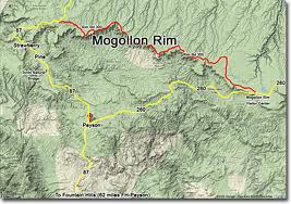
Mogollon Rim for camping and radio fun...
August 14th through 16th, click
here for interactive
map to camp site...
August 14th through 16th, click
here
for interactive map to camp site.
N7Q is
the special event call sign that has been assigned to the Queen Creek
Amateur Radio Club for this special event.
Amateur Radio Special Event Instructions
Our special event station will operate from Friday morning
(about 15:00 UTC), August 15th until Saturday Afternoon till about 2 PM local
time (19:00 UTC).
Check back here for HF and VHF/UHF event frequencies.
HF Frequencies: 7.158 Mhz LSB, 7.178 LSB - HF
Frequencies will be posted in Real Time at DXCluster and this web page,
www.n2qoj.com/n7q.htm
VHF/UHF Frequencies: 146.5 Mhz Simplex FM, Mt.
Ord 146.920 (-) PL 162.2 Mhz, 2M SSB by Sked
Live and Recorded Streaming Video:
Arizona-Joe
If you logged a QSO with N7Q and would like to receive a
Special Event Certificate, just send an email with your request containing call
sign, date, time, and frequency of QSO, to Joe, N2QOJ at
jsammartino@gmail.com. An PDF
version of the certificate will be sent to you once the QSO is verified.
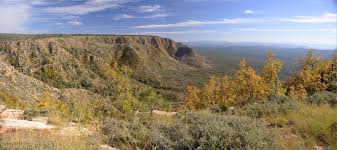
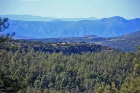
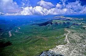
Here's a description of the Mogollon Rim from Wikipedia:
The Mogollon Rim is a topographical and geological feature running across
the U.S. state of Arizona. It extends approximately 200 miles (320 km) from
northern Yavapai County eastward to near the border with New Mexico.
The Rim is an escarpment defining the southwestern edge of the Colorado
Plateau, and along its central and most spectacular portions is
characterized by high limestone and sandstone cliffs, namely the Kaibab
Limestone and Coconino Sandstone. It was formed by erosion and faulting,
and dramatic canyons have been cut into it, including Fossil Creek
Canyon and Pine Canyon. The name Mogollon comes from Don Juan Ignacio
Flores Mogollón, the Spanish Governor of New Mexico from 1712 to 1715.
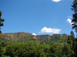
Much of the land south of the Mogollon Rim lies 4,000 to 5,000 feet
(1,200 to 1,500 m) above sea level, with the escarpment rising to about
8,000 ft (2,400 m). Extensive Ponderosa Pine forests are found both on
the slopes of the Rim and on the plateau north of it. The Mogollon Rim
is a major floristic and faunal boundary, with species characteristic of
the Rocky Mountains living on the top of the plateau, and species native
to the Mexican Sierra Madre Occidental on the slopes below and in the
Madrean sky islands (high, isolated mountain ranges) further south.


The Rim is an escarpment defining the southwestern edge of the
Colorado Plateau, and along its central and most spectacular
portions is characterized by high limestone and sandstone cliffs,
namely the Kaibab Limestone and Coconino Sandstone. It was formed by
erosion and faulting, and dramatic canyons have been cut into it,
including Fossil Creek Canyon and Pine Canyon. The name Mogollon
comes from Don Juan Ignacio Flores Mogollón, the Spanish Governor of
New Mexico from 1712 to 1715.
Much of the land south of the Mogollon Rim lies 4,000 to 5,000 feet
(1,200 to 1,500 m) above sea level, with the escarpment rising to
about 8,000 ft (2,400 m). Extensive Ponderosa Pine forests are found
both on the slopes of the Rim and on the plateau north of it. The
Mogollon Rim is a major floristic and faunal boundary, with species
characteristic of the Rocky Mountains living on the top of the
plateau, and species native to the Mexican Sierra Madre Occidental
on the slopes below and in the Madrean sky islands (high, isolated
mountain ranges) further south.
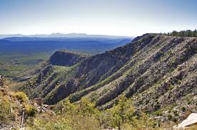
The Mogollon Rim's limestones and sandstones were formed from sediments
deposited in the Carboniferous and Permian Periods. Several of the Rim's
rock formations are also seen on the walls of the Grand Canyon. In many
places, the Rim is capped or even buried by the extensive basaltic lava
flows.
The uppermost sandstone stratum of the Mogollon Rim, called the Coconino
Sandstone, forms spectacular white cliffs, sometimes several hundred
feet high. This formation of the Permian Period is of aeolian
(windblown) origin and is one of the thickest sand-dune-derived
sandstones on earth.
Cities and towns near the Mogollon Rim include Payson, Sedona, Show Low,
Alpine and Pinetop-Lakeside. The Mogollon Rim is practically bisected by
Interstate 17 which runs north-to-south between Flagstaff and Phoenix.
In June 2002, the eastern portion of the Mogollon Rim was the site of
Arizona's second-largest wildfire, the 470,000-acre (1,900 km2) Rodeo-Chediski
fire. The Mogollon Rim was also the site of the "Dude Fire" that started
on June 25, 1990. This fire grew to cover over 30,000 acres (120 km2)
and killed six wildland firefighters. Other large fires have burned
along the Mogollon Rim since 1990, and the area's ponderosa pine forests
remain vulnerable because of past fire-suppression efforts and the
buildup of available dry fuel.
The western novel author Zane Grey built a hunting cabin on the slopes
of the Mogollon Rim just northeast of Payson, above Tonto Creek. This
cabin was restored by the Phoenix air-conditioning magnate William
Goettl during the late 1960s, but it was destroyed by the Dude Fire in
1990. The novel-writer Louis L'Amour's novel The Sackett Brand, set near
the Mogollon Rim, includes descriptions of its cliffs.